
Boundary Survey Cost: Is It Worth the Price?
 If you are trying to decide whether a boundary survey cost is justified for your situation, the answer usually comes down to one thing: what is at risk if the lines are wrong. For most property owners, the price of a boundary survey is a small number compared to what a boundary mistake can cost later. Here is what you should know before you decide.
What a Boundary Survey Actually Does
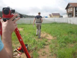
A boundary survey identifies the exact legal edges of a property and marks them on the ground. The surveyor studies the recorded deed, reviews plat maps, checks county records, and physically locates or sets corner markers in the field. The result is a formal drawing that shows where your property begins and ends, where structures sit in relation to those lines, and whether anything crosses a line that should not.
This is different from other survey types. A topographic survey maps the physical surface of the land. An as-built survey documents what was built. A boundary survey focuses specifically on legal ownership lines. That distinction matters when you are trying to figure out whether the price is worth it for your particular need.
When a Boundary Survey Is Worth the Cost
There are situations where skipping a boundary survey creates a real financial risk. These are the most common ones.
Before building close to a property line. Setback rules require structures to sit a certain distance from the legal boundary. If the assumed line is off, a structure can be built in violation of zoning rules or on a neighbor’s land. Fixing that problem after the fact is far more expensive than the survey would have been.
Before buying a property with unclear lines. Older parcels sometimes have boundaries based on older deed descriptions that were never verified in the field. Buying without a current survey means taking on any problems with those lines, including encroachments that already exist.
When a neighbor dispute comes up. If a fence, structure, or driveway is close to a shared line and a dispute arises, a boundary survey gives both parties a factual, legally documented answer. Without one, the dispute stays based on assumption rather than evidence.
Before selling land. Buyers and lenders often want current survey documentation before closing, especially on larger or rural parcels. Having one ready can prevent delays and negotiation complications late in the process.
When You May Not Need One Right Away
A boundary survey is not always the first step. There are cases where the cost is not immediately necessary.
If your property is a standard platted lot in a subdivision and you only want a general idea of where the lines fall, the recorded plat on file with Mohave County already shows that layout. You can review it at no cost through the county assessor or recorder’s office. The plat is not a substitute for a survey if you plan to build or if a dispute exists, but it can answer basic questions without any cost.
If a recent survey already exists and nothing on the land has changed, that document may still be usable depending on the purpose. Ask the surveyor whether an existing survey is sufficient before ordering a new one.
What Determines the Boundary Survey Cost
The price for a boundary survey reflects the specific work involved in your property, not a fixed rate for all jobs. A few factors shape the final number more than others.
Whether corner markers exist. If the original survey pins are still in place and findable, the job moves faster. If they are gone or buried, the surveyor has to do additional work to re-establish them. In desert areas, markers can be buried by sand drift, shifting soil after storm events, or overgrown desert brush. Each of those adds time.
How many sides the property has. A standard rectangular lot has four corners. A parcel with six, eight, or more corners takes longer to measure, check, and document. The more corners, the more fieldwork and drafting time involved.
Whether a formal drawing is included. Some boundary surveys include a full signed and stamped plat drawing. Others provide only a field report. If your lender, title company, or permit office requires a formal plat, confirm upfront that the quote includes one.
Who Pays for a Boundary Survey
There is no state law in Arizona that requires one party in a real estate transaction to pay for a survey. It is a negotiable item, and the outcome depends on the deal.
In most residential sales, the buyer orders and pays for the survey if one is needed. In commercial transactions, lenders typically require an ALTA survey, and the cost is usually the buyer’s responsibility. When a boundary survey is ordered to resolve a neighbor dispute, the property owner who initiates it generally pays the cost.
If both neighbors benefit from having clear documentation, they sometimes agree to split the cost. This is not a formal arrangement but it does happen. There is no rule against it.
How Long a Boundary Survey Stays Current
A boundary survey does not expire on a set date. It documents the state of the property at the time the work was done. For most residential sales, lenders and title companies accept surveys that are less than six to twelve months old. Some will accept older surveys if nothing on the property has changed. Others require a new one regardless.
If your property has been modified since the last survey, such as a structure being added, a fence moved, or a recorded easement changed, a new survey is usually needed to reflect those changes.