
How to Find Property Lines on Your Land
 Knowing how to find property lines is something most homeowners only think about when a problem comes up. A neighbor builds a fence. You want to put up a shed. A buyer asks for documentation. Suddenly, the exact location of your property lines matters a lot. The good news is there are several ways to find them, and some cost nothing at all.
Start With the Recorded Plat
If your property is part of a subdivision, the first place to look is the recorded plat. A plat is a formal map created when the subdivision was originally developed. It shows a lot of dimensions, boundary lines, and the location of streets and easements. Most recorded plats are on file with the county recorder and available to the public at no charge.
In Mohave County, you can request a copy of the recorded plat through the County Recorder’s office. Many counties also make these records available online through their assessor or recorder websites. The plat gives you the legal dimensions of your lot as they were recorded, which is a solid starting point.
Keep in mind that a plat shows what was planned, not necessarily what exists on the ground today. Markers may have moved, errors may exist in older records, or lot corners may never have been physically placed in the field. The plat is useful for getting oriented, but it is not the same as a physical survey.
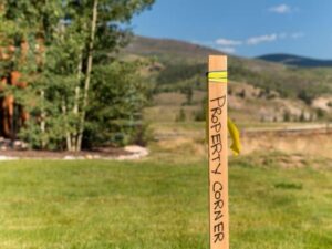
Check for Existing Survey Markers
Many properties already have survey markers in place from a previous survey. These markers are usually metal pins or rebar driven into the ground at the corners of the lot. They can be at or just below the surface, which makes them easy to miss.
A metal detector is one of the most practical tools for locating buried survey pins. Walk the approximate corners of your lot and scan the ground slowly. When the detector signals, dig carefully. If you find a metal pin, it is likely a survey monument set by a licensed surveyor at some point in the past.
In the desert Southwest, markers can be buried by shifting sand, covered by caliche crust, or pushed aside by roots from desert shrubs. Do not assume that because you cannot see a marker it does not exist. Searching the area with a metal detector first is worth the effort before assuming the corner is missing.
Do not move, remove, or alter any marker you find. It is illegal in Arizona to disturb survey monuments, and doing so can create serious legal problems for you down the line.
Review Your Deed Description
Your property deed contains a legal description of the land. This description uses one of a few standard formats. Some descriptions reference a recorded plat by lot and block number. Others use a metes and bounds format, which describes the boundary in terms of directions and distances starting from a known point.
Reading a metes and bounds description is not always straightforward, but the information inside it tells you exactly how the boundary was recorded. If the description starts at a named landmark or monument and traces the boundary in measured steps, it can help you understand where lines should fall even before hiring a surveyor.
Your deed is usually available through the Mohave County Recorder’s office or through the title company that handled your closing. If you do not have a copy, requesting one is simple and inexpensive.
Use Online Parcel Mapping Tools
Most county assessor websites now include an interactive parcel map. These tools let you search your address or parcel number and view an outline of your property overlaid on aerial imagery. Mohave County provides parcel map access through the county assessor’s website, where you can view lot boundaries, neighboring parcels, and basic property information.
These maps are useful for getting a general picture of where your property sits in relation to surrounding lots. They are not survey-accurate, and they should not be used to place fences, mark construction limits, or resolve legal disputes. But they are a helpful first step for visual orientation at no cost.
When a Licensed Surveyor Is the Right Answer
The methods above help you understand the general location of your property lines. But if you need to know exactly where those lines are for construction, a fence, a legal matter, or a property sale, a licensed surveyor is the only reliable answer.
A surveyor brings the tools, training, and legal authority to locate, verify, and mark the actual boundaries of your property. They research all relevant recorded documents, perform field measurements, and place physical markers that hold legal standing. No app, map, or metal detector provides that level of accuracy or legal weight.
In Arizona, surveyors are licensed by the Arizona State Board of Technical Registration. Only a licensed professional can certify survey measurements. When the stakes are high, that certification matters.
What Affects How Hard Property Lines Are to Find
Some properties are straightforward. Others take more work. Several factors make lines harder to locate without professional help.
Age of the property. Older parcels may have been described using landmarks that no longer exist or surveyed with equipment far less precise than what is used today. The older the parcel, the more likely it is that lines on the ground do not match what was recorded.
Rural or undeveloped land. Parcels in rural parts of Mohave County often have fewer nearby reference points and may not have been formally surveyed in decades. Corners on these properties are harder to find and take more time to re-establish.
Prior development activity. Construction, grading, fencing, and landscaping can all disturb or bury survey markers over time. The more activity a property has seen, the more likely it is that original markers have been moved or covered.
Frequently Asked Questions
Can I find my property lines for free?
Yes, for a general idea. Recorded plats, online parcel maps, and your deed description are all available at little or no cost. But for a legally accurate location of your lines, you need a licensed surveyor.
What do survey pins look like?
Survey pins are usually short metal rods or rebar driven into the ground, often with a small plastic cap that identifies the surveying company or license number. They sit flush with or just below the surface, which is why they are easy to miss without a metal detector.
Is it illegal to remove a survey marker?
Yes. Removing, moving, or destroying a survey marker is a crime in Arizona. If you find a marker on your property, leave it in place. If you suspect a marker has been moved, contact a licensed surveyor rather than attempting to relocate it yourself.
Do property lines always follow fences?
No. Fences are placed by property owners and are not always on the legal boundary. A fence line and a property line are two different things. Many boundary disputes arise because a fence was placed based on an assumption rather than a survey.